CHAPTER III
METHODOLOGY
This research attempts to answer the issue of food security with a new approach. This study assesses food security by evaluating the location of grocery stores and the availability of specific food items instead of trying to determine food security via standardized questioning. The definition of "food security" is applied to the situation of Akron, Ohio in a thorough fashion to accomplish this.
Food security is approached from the perspective of the consumer, not the grocery store owner. Rarely has location analysis been done from the perspective of the consumer or citizen. Since the beginning of grocery store analysis in the early 1930s, the focus has been on grocery companies wanting to know their trade areas and market share. Later, it continued to be used by businesses as they developed planned shopping centers (Applebaum, 1968).
To determine food access, a key component in food security, all the stores in a defined study area in Akron were visited, and information on grocery stores and the conditions of those whom the stores serve were gathered. The following explains how this was done.
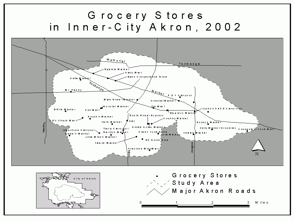
The study area was delineated by selecting an area within a half-mile buffer (in which the average human can walk within roughly ten minutes) around all census tracts that had a 1990 mean household income of 150 percent of the poverty threshold. The 1990 Census is the most recent data on the tract level for Summit County (where Akron is located). Even though the 2000 Census has been conducted, information aggregated on that scale will not be available until after this research is completed. The 150 percent boundary was chosen as it includes those already technically in "poverty" and those bordering on or at risk of poverty. The poverty threshold is dependent upon the mean household size of each particular tract.4 A map of the study area and surveyed grocery stores is in Fig. 1.
Food stores were identified from a number of sources: an on-line phonebook from US West, called www.qwestdex.com; the December 2001 edition of the SBC Ameritech yellow page directories; and a listing from the Akron Regional Board of Development tracking retail stores from 1995. All stores that did not sell food as a their primary item of sale (such as gas stations and department stores) and non-Akron city stores were eliminated from this list.
Using this directory listing and the defined study area, a total of 38 stores were surveyed (Fig. 1). The addresses on this list were mapped using ArcView 3.2. This process was double-checked and subsequently corrected for inaccuracies. A number of stores that were missed by the initial directory were added as soon as they were located. Also, some stores said to be in the study area were sometimes not found once the author arrived at the address, while others had since been closed.
Figure 1. Grocery Stores in Inner City Akron, 2002
A large supermarket in an affluent neighborhood outside of the study area was surveyed as a control. This store provided data that is used to compare with the results of the study area.
Restaurants or other "eat-out" establishments, and emergency food supply locations such as homeless shelters, the Salvation Army, food banks, Meals-on-Wheels, or reduced-school lunch programs were not included in the definition of "food store". The vast majority of food is still purchased from food stores, and despite the increase in "eating-out" and food bank usage, the food stores remain an important component of the urban food system. Grocery store costs fall in-between the more expensive "dining-out" option and the free emergency food sources, but this is only when evaluating cost in economical terms, not necessarily time or effort.
The researcher visited each store during the period of December 6, 2001 to January 14, 2002. Upon arriving at a store the manager or owner was approached, given an explanatory letter, and informed about this research project (Appendix 1). Permission to look about the store and gather data was requested and granted at all stores.
The data gathered for each store included: store name, address, hours of operation, acceptance of food stamps and WIC, the approximate size of the store, and date visited (Appendix 2). Then, using a list of 42 food items, it was noted whether the store had each item, and if so, the most cost-efficient item's price, unit size, and brand (Appendix 3).
The list of 42 food items were drawn from Hogbin, et al. (1999), a USDA listing of low-budget and healthy food purchases for a family of four for a two-week period. Items for this study were chosen that appeared on both weeks of the two-week "grocery lists" suggested by the USDA. The format (i.e. frozen, fresh, packaged, canned, etc.) of the food item was preserved with the recommendations while surveying, for example only frozen peas, canned green beans, and fresh carrots, and so forth. There were only two variances on this rule-liquid orange juice was accepted, and both dry and canned kidney beans. During the surveying, a few previously unspecified restrictions on varieties and flavors were made: white or wheat bread loafs, spaghetti noodles, any form of turkey or chicken, and Italian salad dressing.
The researcher used the ArcView extension "Network Analyst" to determine service areas of the food stores. It traverses the available roads and routes, finding how far away one can be from a given store in order to reach it in a certain amount of time or distance. Network Analyst uses the concept of the "Manhattan distance" that is only established routes. It eliminates distance calculated "as the crow flies", which is sometimes a possibility for non-automobile travel.
All the demographic information comes from the 1990 US Census and relies upon the proportion of block group that fell within a given service area. Thus, if a service area happened to contain one-quarter of a specific block group that had a 4000-person population, it was assumed that the population was evenly distributed, and thus 1000 people of that block group were within the store's service area.
[4] The table explaining poverty threshold can be found on the Internet here: http://www.census.gov/hhes/poverty/threshld/thresh90.html